
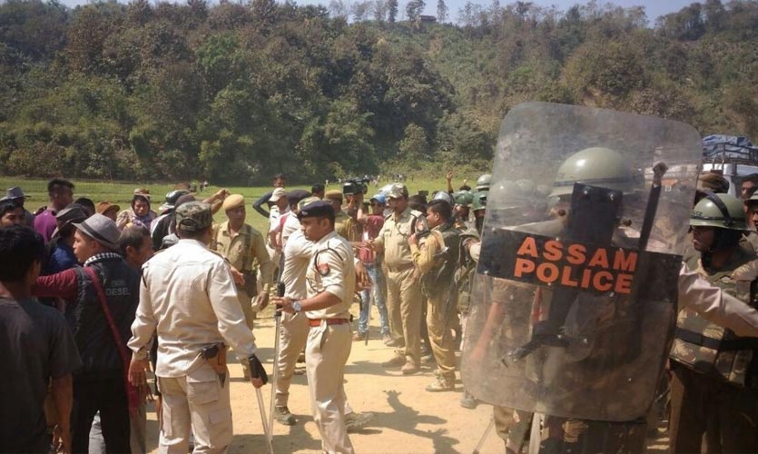
Five Assam Police officers were killed and 50 others were injured when Assam and Mizoram police officers reportedly opened fire on each other on Monday, escalating the border conflict between the two states.
The confrontations are the result of a land dispute between Assam and Mizoram over “inadequate delineation of the state boundary”. During the British administration, two border notices were issued.
The Source Of Unrest
As the British government in India expanded their regime in the northeast at the beginning of the century, they used Assam as a springboard to annex sections of land claimed by local tribes. As a result, by the time of Independence, a large portion of the northeast was engulfed. Assam was eventually divided into four states: Nagaland, Meghalaya, Mizoram, and Arunachal Pradesh. However, the new states established were not fully satisfied with the delineation of boundaries.
Difference in perceptions and politics are at the heart of the conflict. NDTV India reported that the borders of these states were constitutionally established as each was formed out of Assam. The narrative of Nagaland, Mizoram, and Meghalaya is that they have been robbed of areas that were traditionally theirs. Access to resources and their rights to territory are at risk, both of which no state wants to relinquish.
Since tensions on the Assam-Mizoram border have escalated, confrontations have also occurred on Assam’s borders with Nagaland, Meghalaya, and Arunachal Pradesh. According to the Hindu, border commissioners placed to resolve these conflicts have had little success since the governments have been unwilling to accept their non-binding conclusions.
Assam’s Position
According to the Himanta Biswa Sarma-led administration, the controversy began when Mizoram began construction of a road towards Rengti Basti and “destroyed” the Inner Line Forest Reserve in Lailapur, reportedly violating the current status quo of the Assam-Mizoram boundary. After the Assam Police went to check on the installation of an armed camp in the disputed Lailapur region, a mob of miscreants led by Mizoram police reportedly attacked them.
Over 50 Assamese police personnel were critically injured in the incident, with at least five of them confirmed killed.
Mizoram’s Position
The Mizoram administration has issued a contradictory account of events. According to Mizoram Home Minister Lalchamliana, about 200 Assam police officers arrived at the Vairengte auto rickshaw stop and overran a state police duty station. He claims the Assam Police used lathi charges and tear gas on unarmed citizens who arrived at the scene to ask about the situation, resulting in several casualties. According to him, the Mizoram Police opened fire on their Assam counterparts only after they shot tear gas grenades.
Background
Mizoram was known as Lushai Hills before becoming a Union Territory in 1972 and was granted the status of a sovereign state in 1987. These hills of Mizoram state, presently known as Mizo Hills, are related to the current issue.
The Mizo tribes, who considered the Lushai Hills to be their home, battled with the British colonialists when they moved down southern Assam’s Cachar region in search of places to plant tea. Following violent clashes, the British authorities reached deals with the tribals to recognise their territorial claims and to exclude the tribal lands from the application of British laws in India. The colonialists also established the Inner Line system, which safeguarded these indigenous regions from outside intrusion.
A demarcation of Cachar from the Lushai Hills agreed upon by the Mizo tribes and the British was officially recognised in 1875. However, when the colonialists expanded their influence in the northeast, the map of Mizoram was redrawn and a new delineation was established in 1933. Mizoram, on the other hand, claims that this was done unilaterally.
Mizo lawmakers maintain that the 1875 delineation was the “only border created in cooperation with our leaders [and]… is the genuine boundary as it was done per the agreement between the Mizo Chiefs and the British government.” They further claim that “when the line was drawn in 1975, we were not consulted,” and so the boundary was “forced”.
As a result, the 1875 boundary separating the Cachar Hills from the Lushai Hills, as well as the 1933 notification separating the Lushai Hills from Manipur, are at the heart of the conflict between Mizoram and Assam. The Mizo Assembly was informed that the “difference between the former border of 1875 and 1933 is 749 square kilometres”. Assam and Mizoram share a 164-kilometre border, with three Assam districts – Cachar, Karimganj, and Hailakandi – touching the three Mizoram districts of Aizawl, Kolasib, and Mamit.
Read more: What Is The #SaveBuxwahaForest Movement?
Violent confrontations have occurred in the past as a result of the Assam-Mizoram border dispute, with reports dating back to the 1970s. Nevertheless, a significant flare-up happened in 2020, followed by the fighting this year. Assam has a BJP administration in charge and the party is also associated with the neighbouring state’s Mizo National Front-led administration.
Lt. Gen Shokin Chauhan writes in a Financial Express column that the Centre can help resolve internal border disputes “by either persuading the concerned states to come to the negotiating table and seek a solution or by establishing a boundary commission whose recommendations would be binding on the parties involved”. News18 reported that following clashes on Assam’s border with Nagaland in 2014, then-chief minister Tarun Gogoi said, “several border commissions have been established to settle the issue with Nagaland, Arunachal Pradesh, and Meghalaya, but the other states have not accepted the recommendations of these panels.”